in training

An added dimension to the poodlewalks is that I am starting to train for the 14 day camel trek in late in May 2021 from Blinman to Lake Frome. This forthcoming camel trek is part of this project.

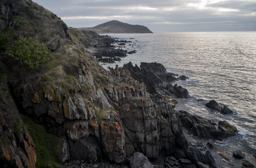
So I have started to walk to and over Rosetta Head, run up the steps twice at Petrel Cove, and increase the poodlewalks to 90 minutes. I’ve started doing the Rosetta Head route with Kayla on Sunday mornings when Suzanne is walking on her loop route. I really need to increase my cardio and to toughen up my feet.

look west from Rosetta Head

Building up my strength and cardio is going to be long and slow as, unlike Suzanne, I am currently not going to the gym. My exercise levels and muscle strength have dropped unfortunately. These need to be substantially increased.

coastal waterfall

I have moved away from walking in the local bushland or the back country roads. It is dry and dusty with brown snakes and the ground is full of grass seeds. I now walk along the coastline and the various beaches. This limits the possibilities that I have for film photograph.

Film photography has come to the fore now that Light Paths is up and running, and Thoughtfactory’s Newsletter #3 has finally gone out. I want to do some large format photography–using the 5×7 Cambo monorail–as I am tired of sitting in front of a computer screen all day.

waterfall, Waitpinga

The above coastal waterfall is one possibility that I have in mind. I checked the location out yesterday afternoon when I was walking with Maleko to Kings Beach. The water flow has eased now that the rains have stopped and the hot, dry weather is returning. That means it is now possible to stand on the rocks with a tripod—just.

a welcome break

Suzanne has been away in Brisbane this past week and so Kayla, Maleko and myself have been hanging out at Kings Beach and Kings Head. There is no one around here apart from the Heysen Trail walkers making their way back to their cars parked at the Kings Beach Rd lookout. That lockout has become a bit of a destination.

granite, Kings Head, Waitpinga

These afternoon poodlewalks are a welcome break from sitting in front of a computer during the day, working on the Abstraction: Different Interpretations exhibition at Encounters Gallery, building the Light Paths website, and writing the third Thoughtfactory newsletter and well as the introductory newsletter for Light Paths.

Waitpinga bushland

As part of building up some supplementary images as a background for the forthcoming online walking/photography exhibition at Encounters Gallery I have been photographing in a small patch of bushland in Waitpinga. I needed a contrast to the Littoral Zone images.

bushland, Depledge Rd, Waitpinga

The roadside vegetation that I see whilst walking the back country roads is limited in terms of photographic subject matter. So I have been wandering and exploring this bushland on both the early morning with Kayla and at the late afternoon poodlewalks with Maleko.

self-isolation

We arrived back from a 2-3 week holiday in the lower part of the South Island in New Zealand on Monday night (the 23rd March), and immediately began our mandatory 2 weeks of self-isolation. We just made it back to Australia before New Zealand locked down–a nationwide shutdown– on Wednesday, and Virgin had cancelled all its international flights in response to the coronavirus pandemic.

I walked Kayla along the coastal rocks the morning after our return before sunrise in order to avoid other people. There was one runner on the Heritage Trail, and the Green Car man was walking amongst on the rocks with his aggressive Australian Blue Heeler on a lead. I was able to keep a large distance from both of them. Other than that there was no one around and I entered no buildings.

granite

It was a mild and overcast morning. The landscape looked so very dry compared to Fiordland or to Dunedin. Though it started to rain as we made our way back to the car at Petrel Cove, the rain didn’t last long and it was very light. It wasn’t enough to green a browned landscape.

cliffs and ocean

On a recent poodlewalk to Kings Head and beyond one overcast morning in February I made a few photos of the cliffs I was walking along. This snap is looking back to Rosetta Head, or The Bluff:

Rosetta Head

The next morning we clambered down the cliffs via the dried up waterfall to the rocky foreshore as I wanted to make a photo of the cliffs and sea with the early morning light on the rocks.

revisiting Kings Head

Suzanne is currently walking on Lord Howe Island and I’m minding the poodles until I leave to join the Friends of Photography Group (FOPG) at Mt Arapiles in the Wimmera plains. I leave on Friday 6th September, Suzanne returns to Adelaide on Sunday, 8th September, and I return to Encounter Bay several days latter.

FOPG have a weekend photo session at the Mount Arapiles-Tooan State Park, which is south of Nhill and the Little Desert National Park. Camping at this site will be the first time that I have linked up to this Melbourne-based large format photography group in the field. After this photo camp I will move on to stay at Lake Marma at Murtoa to photograph in the Wimmera Mallee.

2 cuttlefish shells, Kings Head

Looking after the two poodles on my own means that the areas where they can walk off lead are restricted, as I need to avoid the kangaroos in the morning and other walkers in the afternoon. So it is back to the old standbys, such as meandering amongst the coastal granite rocks around the foot of Kings Head.

Ho-Hum + the tourist gaze

After my return from the Overland Corner Reserve trip I felt a bit deflated when I was walking along the coastal beaches in both the early morning and the late afternoon. Photographing whilst walking in the littoral zone along the these beaches seemed a bit ho-hum, low key and rather mundane. I even started to toss up taking a camera with me.

Mundane and ho hum because I am back to photographing seaweed again whilst I am walking along the Esplanade town beach with Kayla early in the morning before sunrise. I arrange this walk so that I am making my way through the clusters of seaweed after sunrise whilst consciously trying to avoid the way the tourist’s gaze aestheticizes this seaside resort.

seaweed, Esplanade Beach

There is a sense of dull repetition in that I keep doing the same thing over and over again, without really knowing what I am going to do with all these coastal images. It is becoming a bit routine if not automatic.

Inman River walks

During the autumn of 2018 I made a number of afternoon poodlewalks with Maleko and Kayla along a couple of the walking trails by the Inman River. One of these trails was a walk around the small redgum loop trail by the river near Armstrong ( Ring Route ) Rd. I did this several times, including a few in the morning, before the trail became flooded. On the odd occasion on the redgum woodland loop walk I photographed with a film camera.

Another walk we sometimes did was the linear one along the floodplain on the eastern side of the river amongst that is populated by kangaroos. We would start from the old SA Water waste treatment plant on Canton Place and then make our way along the redgums on the floodplain to where the river passed the Victor Harbor cemetery. We would then slowly make our way back to the Forester in Canton Place as dusk started to fall:

Inman River floodplain

I meant to return to the floodplain area during the winter of 2018 when the river was flowing with a film camera and tripod, but I never did. I only ever scoped the floodplain as I found the floodplain difficult to photograph: just trees, a dry river bed, and leaves on the ground.

Agricultural landscapes

As mentioned in this post on my Encounter Studio blog I have started to explore the back country roads and the agricultural landscape in and around Waitpinga whilst on our afternoon poodlewalks. The Fleurieuscapes project needs to include the rural landscape in order to have some balance to the coastal images in the littoral zone. Most of the space of the Fleurieu Peninsula is an agricultural landscape consisting of dairy farms, grazing land for sheep and cattle, and the rapidly expanding vineyards.

I do struggle with photographing this subject matter, and most of what I see and then scope with a digital camera on our poodlewalks is boring and uninteresting, especially when I look at the digital files on the iMac’s computer screen. I am finding it to be a depressing and disheartening process.

One exception is this picture of pink gum, with a farm shed, silo and water tank along Pitkin Rd in Waitpinga that I came across on an exploratory afternoon poodlewalk with Kayla and Maleko:

Pitkin Rd, Waitpinga

This scoping picture was made in the autumn, when I first started to consciously explore the back country roads in Waitpinga. This picture of a dry, agricultural landscape works much better for me in black and white. The initial colour image looks too pretty and touristy–the photos would be what you would see in a feature in the glossy Fleurieu Living Magazine.