As a break from working on, and uploading, some of the digital work from the Wellington trip, I’ve been figuring out to photograph trees, and, more generally, the local remnant scrub along the coastal sand dunes and on the roadside vegetation along the back country roads.
coastal tree
I see lots of trees on our poodle walks, and I’m finding it hard to both photograph them and do it well. Most of the tree images for the forthcoming Fleurieuscapes photographic exhibition at Magpie Springs never made it past the second cut. That says that I need to lift my game. Continue reading “photographing trees”
The early morning poodlewalk today was along the beach between the mouth of the Inman River and Police Point near the Granite Island causeway in Encounter Bay. This is the beach east of Kent Reserve and I call it the Esplanade beach in the absence of any official name.
I wanted to have a closer look at the erosion along this section of the beach and to see how the Victor Harbor Council is planning to protect this part of the coastline from the sea eroding the foreshore and the sand dunes. I knew that sections of the foreshore along the Franklin Parade seawall is under threat from sea level rise and storm surges and that it requires upgrading.
After returning from the Wellington trip the early morning poodle walks in Victor Harbor have been around Rosetta Head (The Bluff). We—Ari, Kayla and myself– have started walking on the Bluff at sunrise. This is just before 6am during the early summer months.
Encounter Bay, 6am
I’m still interested in photographing the landscape around The Bluff in the early morning light now that summer is here, and the local landscape has that dried brown look. Continue reading “Rosetta Head, Victor Harbor”
This will be the last poodlewalks for a week or so as we are off to Wellington, New Zealand tomorrow for a few days. We managed to obtain some dirt cheap promotional air tickets, and we decided to use them to drive north to explore the Tongariro National Park —and, hopefully, to walk the Tongariro Alpine Crossing.
A friend–Heather Petty-— is staying at our Encounter Bay house and looking after Kayla and Ari for a week whilst Maleko is staying at the house of a dog minder in Victor Harbor. That enables Suzanne and myself to get away together, which is a change from the separate trips we have done recently.
twig + rocks
Although I grew up in Christchurch NZ, and worked in Wellington as an economist, I haven’t been to the Tongariro National Park nor the North Island Volcanic Plateau. I did travel though the plateau by train to Auckland once. It was at night so I didn’t see much.
So I’m not sure what to expect photographic wise whilst walking the Tongariro Alpine Crossing, as many of the images that I’ve seen are from the air. From what I can see from the pictures on the internet most of the walk is on raw volcanic terrain with no vegetation. Continue reading “off to New Zealand”
This picture was made whilst I was walking with the three standard poodles around the lagoon of the Hindmarsh River at Encounter Bay, Victor Harbor, late in the afternoon:
Hindmarsh Lagoon
I was scoping as usual— looking for photographic subjects whilst on the poodlewalks.
Basically I am teaching myself how to photograph the bush and, to a lesser extent, the foreshore along the southern coast of the Fleurieu Peninsula. The latter work is mostly abstractions of the rocks on the coastline. Continue reading “along Hindmarsh lagoon”
Suzanne is currently away walking in the Mt Remarkable National Park around the Alligator Gorge area. It’s a short walking holiday based at Alligator Lodge with some friends from the Larapinta walk that they did earlier in 2015. She will explore the Mt Remarkable area again next year when walking section 43 of the Heysen Trail. Hopefully, Suzanne will scout for some good photographic sites.
I’m at Encounter Bay minding the 3 standard poodles and looking for areas to walk in the morning and evening, which are away from people and grass seeds. In the morning that requires me to be walking on the beach at Encounter Bay before everyone else comes out, take a quick photo of objects near the sand dunes, then move on. We are generally back home by 7am.
iron + wood, Hayborough
In the evening the best option is to walk to Kings Beach in Waitpinga, then hang out around Kings Head because nobody goes there other than the odd surfer when the waves are rolling right. People prefer the beach to the rocky outcrops and so they miss the dolphins cruising by around the headland. The Heysen Trail walkers go over the top of Kings Head on their way to the Newland cliffs. Continue reading “an open air studio”
Whilst Suzanne has been away walking the Heysen Trail around the Kapunda and Burra area in South Australia this week, I’ve been minding the standard poodle, processing and uploading some of the images from my road trips early this year, and planning the Mallee Highway silo project for next winter. I’m very limited in where I can go walking at the moment because I have to stay in, and around, areas that are from the dam grass seeds. They are everywhere.
I have been limited to walking along the coastline at such places as Kings Beach and Kings Head where there are few people. Or walking along the country roads that are part of the Heysen Trail and that don’t have that many grass seeds amongst the roadside vegetation.
rockface, Kings Head
I cannot do much photography when I am walking with three dogs. I have to keep an eye on the dogs rather than use the poodle walks to look for photographic opportunities: Continue reading “struggling”
My time recently has been spent working on the website’s various galleries Two of the earlier portfolios are now pretty much in place—Bowden and Port Adelaide. They look pretty good. The next step is to reconfigure the rest of the portfolios in this carousel style.
The daily poodle walks in both the morning and evening have been just quicker walks with little time being spent on scoping photography. The grasses are rapidly drying out on the coast and they represent a real problem as they hook onto the standard poodle’s coats, and then quickly work their way into the skin. So I am avoiding areas where there are lots of grass seeds.
Rambler, old dump, Victor Harbor
The Rambler picture in the old Victor Harbor dump was one of the last scoping photos that I’ve done. Rambler is slowly falling apart from neglect. Rambler was built by Peter Sharp at Cruickshanks Corner, Port Adelaide in 1875 and it was possibly Australia’s oldest racing yacht.
It used to on the slips at Searle’s Boatyard–in the historic boatyards in the Central Basin of the Port River–before Port Adelaide’s oldest surviving boatyard was closed down to make way for the residential waterfront redevelopment of Port Adelaide. The redevelopment at Newport Quays failed to regenerate Port Adelaide. The development of the expensive dog boxes on the waterfront was scrapped but not before it had successfully destroyed the fabric of the history of the port.
It is sad to see Rambler just being left in the ex-dump site to rot. It needed have been so, since it just wasn’t necessary to destroy the Port Adelaide’s oldest surviving boatyard for expensive dog boxes that never eventuated. Continue reading “a slow decay”
Suzanne and I are currently in the process deciding whether we will stay in Victor Harbor or move back into the south-east corner of the city of Adelaide. The latter is the more capital expensive option (an architecturally designed extension to a cottage) whilst living on the southern Fleurieu Peninsula coast at Victor Harbor means that we are much more isolated. We are currently swinging between staying and going at the moment. There are advantages and disadvantages to both options.
One disadvantage for me in living at Victor Harbor is the limited opportunities that it offers for urban photography–ie., the flâneur, the casual wanderer, observer and reporter of street-life in the modern city. This kind of work now requires either day trips to Adelaide, major trips to Melbourne or road trips. Consequently, my daily photographs made on the morning and afternoon poodlewalks are nature orientated. I do feel constrained by this.
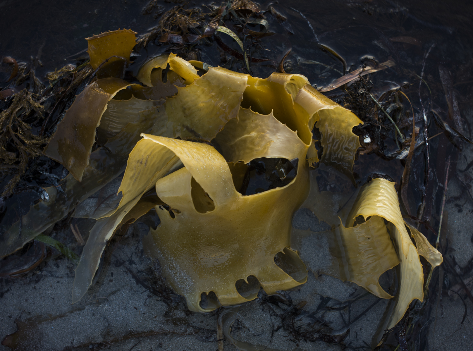
seaweed still life
Hence the idea of quickly constructing the image as a still life whilst on the walks, since it is not really possible to bring the seaweed and rocks back to the studio to photograph. Continue reading “staying or going?”
Winter has passed and spring has arrived in South Australia.
It is becoming warmer and the light is changing very quickly: sunrise is an hour earlier, sunset is an hour latter and the light is more intense and brighter early in the morning and in the late afternoon. The change in the seasons was very sudden.
Old Victor Harbor dump
The warmer weather means that there are more people on the coast, such as joggers, fishermen, dog walkers, walkers, surfies, day trippers, children swimming and playing on the beaches etc, which in turn makes our poodlewalks more complicated. People say that winter on the southern Fleurieu Peninsula coast is to be avoided, as they find it too cold.I enjoy the winter on the coast. Continue reading “Spring”